MobileMap
Built for the Forest. Powered by the Cloud™
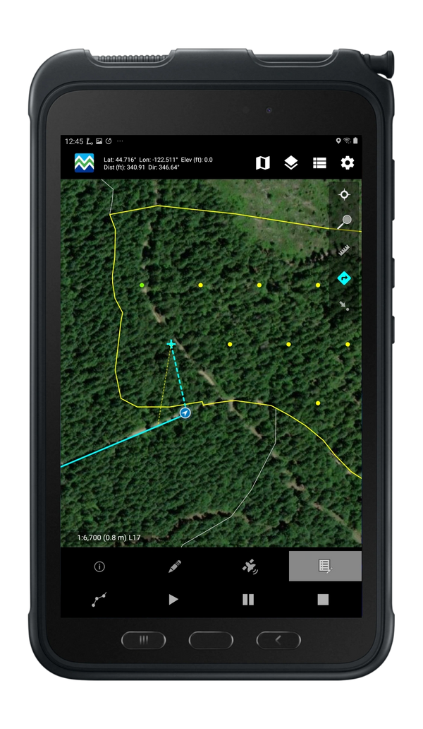
MobileMap™ is the ultimate solution for field navigation, data access and data collection. It is a modern mobile GIS application built for Android devices. MobileMap utilizes cloud-hosted feature services for field data collection and provides access to large quantities of imagery, base maps, and GIS data for offline use. This means great location awareness, efficiency in the field, and improved team collaboration. MobileMap enables near real-time coordination and allows field staff to remain connected, even in the most remote environments.

MobileMap Functionality
MobileMap is a native Android field data collection and GIS application that provides offline access to large datasets and rich base maps. MobileMap focuses on offline field data collection workflows including navigation, GPS data collection, and field mapping. It is used in a range of industries including commercial forestry, state and federal agencies, public utilities, and NGOs. As an Android application, MobileMap takes advantage of the wide range of field-capable mobile devices, including rugged and waterproof offerings from Samsung, Handheld Group and Juniper Systems.
- Download data from your GIS for offline access
- Display rich base maps including high resolution aerial imagery, topo maps, roads, streams, etc.
- Search for data by attribute, easily navigate to selected features
- Collect spatial data using GPS or heads-up digitizing on the map
- Built from the ground up with Esri technology, integrates seamlessly with ArcGIS
- Completely configurable attributes including data type (text, integer, floating point) and allowed values (code lists, range of values)
- Streamlines mobile data workflows for improved efficiency, data currency, and collaboration.
- Tailored solutions for timber cruise and road management
Reach out to our sales team to learn more.
MobileMap Cruise

WSG's MobileMap Cruise is a timber cruising application developed and optimized your forest inventory program. From planning to data delivery, MobileMap cruise delivers professional streamlined cruising software for your project.
- Cruise Design - lay out plots, select plot size, define nested plots and double sampling.
- Navigation - use driving directions, GPS location, dynamically updated path to your destination, distance and bearing. Plot opens automatically when you reach it so you can begin cruising immediately.
- Efficient Cruise - optimized data collection forms for stands, plots, trees and logs. Includes auto-auto-populated fields, smart defaults, robust validation, limiting distance calculations and more.
- Mobile Mapping - use GPS to capture spatial data or heads-up digitize over the map. Advanced map editing includes split, clip, append.
MobileMap Roads

MobileMap Roads integrates with your organization’s GIS to support inventory, inspection, analysis, planning and maintenance for the life cycle of your roads and related assets.
- Optimized Interface - Carefully designed user interface enables one touch capture of road line and point features.
- Flexible Data Model - Supports capture of existing roads, areas requiring road maintenance, vegetation removal, culverts, bridges, intersections, driveways, guardrails, linear pavement markings, ADA ramps, signs and more.
- Simultaneous Capture - Capture multiple GPS features simultaneously to enable GPS capture of culvert, vegetation management and other features while mapping roads.
- Smart Forms - Include auto-populated fields including line lengths, point accuracy, auto-generated IDs, observer name, date and time, photos, and more.
Ready to Purchase MobileMap?
If you are interested in purchasing MobileMap, send a message to our sales team and we will get get back to you.
The new system has enabled us to replace our aging mobile devices and outdated workflows with an easy-to-use, modern system.
- Chris Jordan, Game Land and Forest Resources

Get started with MobileMap
Contact Us
Current Users
Contact Us
Have some specific questions or want to schedule a call with our team? Send us a message and let us know how we can help.
Learn More
Current Users
Contact Us
Want more information about MobileMap? Our searchable knowledge base offers extensive documentation and information on MobileMap.
Current Users
Current Users
Current Users
Use the link below to access our dedicated downloads and licensing site.
Copyright © 2022-2024 Woodland Solutions Group, LLC - All Rights Reserved.
This website uses cookies.
We use cookies to analyze website traffic and optimize your website experience. By accepting our use of cookies, your data will be aggregated with all other user data.